

Ex-Tropical Cyclone Hayley has been downgraded to a tropical low and will continue to weaken throughout Wednesday as it moves further east through the Kimberley, after bringing destructive weather as it made landfall on the Dampier Peninsula on Tuesday night.
Hayley crossed the coast near Djarindjin as a Category 3 System at around 5pm on Tuesday, bringing gusts as high as 158 kilometres per hour at around 6:15pm and 130mm of rainfall to the region since 9am yesterday morning.
As the storm tracked further east, it reportedly made limited impact south of its centre in Derby as well as Broome, which is also said to have been little impacted.
In the Kimberley as of 6:30am WST, a Severe Weather Warning remains in place for further inland parts of the Kimberley, including Mount Barnett and north of Fitzroy Crossing, with warnings for possible heavy rain and flash floods.
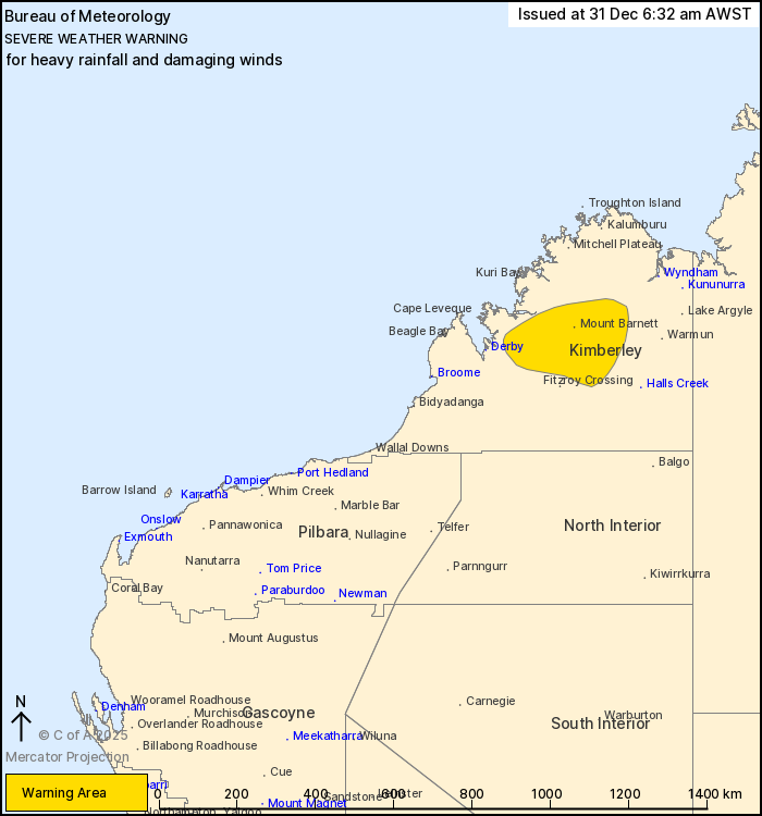
"Heavy rainfall which may lead to flash flooding is possible about the warning area for the rest of today," the Bureau of Meteorology said on Wednesday morning.
"6-hourly rainfall totals between 40 to 70mm are likely, with isolated falls of 100 mm possible. Areas of heavy rainfall are likely to track close to the centre of Ex-Tropical Cyclone Hayley as she moves east and then northeast."
A Watch and Act alert remains in place by the WA Department of Fire and Emergency Services (DFES) for the area south of Beagle Bay and for south to Cape Leveque - close to where Hayley made landfall Tuesday.
"The cyclone has passed however there remains a possible threat to lives and homes," the Department said as of 6:56am WST Wednesday morning.
"DFES is conducting assessments on the ground to identify hazards to ensure the safety of the community."
DFES has advised local residents to protect their health and safety, where protective clothing if cleaning up and to limit movement in the area and be aware of potential hazards while assessments of hazards to the community are made.
Emergency services are working to clear roads of fallen trees, powerlines and other hazards.
The Bureau of Meteorology expects Ex-Tropical Cyclone Hayley to continue to weaken while moving east and over the west Kimberley through Wednesday.
The system was moving east at 21 kilometres per hour as of Wednesday morning while winds of 90 kilometres per hour in the north and near its centre remain possible.
The storm follows Ex-Tropical Cyclone Fina, which brought some damage to the Kimberley after causing widespread damage to Darwin and surrounding areas in the NT, including the Tiwi Islands, as a Category 3 and 4 system.
On the other side of the country, destructive weather and major flooding is also impacting north and west Queensland, killing one man in his 70s.
Aboriginal communities in or near the warning and floodwatch areas in Queensland included Doomadgee, Mornington Island (Gununa), Burketown, Normanton, Kowanyama, Aurukun, Pormpuraaw, Napranum, Mapoon, Weipa, Hope Vale and Wujal Wujal as of earlier in the week.
Severe weather warnings in the state's north and west remain in place.


