

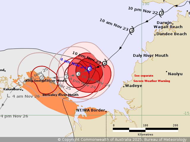
Tropical Cyclone Fina remains a category 4 system, but is expected to weaken before reaching the Kimberley coastline on Monday night.
An update from the Bureau of Meteorology indicates gusts as high 120km per hours between the Western Australia and Northern Territory border and west to the King George River mouth are expected Monday morning, with potential flash flooding from heavy rainfall possible on the Kimberley coast during the day.
Gusts are high as 185km per hour may develop between the King George River and Berkeley River mouths on WA's northern tip from Monday afternoon as Fina makes landfall.
The Tiwi Islands are being warned for large waves and tides, as well as minor flooding for low lying areas throughout Monday and Tuesday.
The same warning applies for the areas between the border and the King George River mouth.
Fina is expected to weaken slightly to a Category 3 system as it tracks slowly west towards the KImberley Coast.
A warning zone is place for the area between the NT/WA Border to east of Kalumburu in WA.
The system is moving at 8kms per hour.
As of Sunday afternoon, power crews were continuing to assess damage in a large number for areas across the NT.
Network outage continued from Darwin to Katherine, and in rural areas.
Crews are set to respond 'as soon as possible' to an outage in Marrakai.
WA Emergency has issued a warning to the areas between the Cambridge Gulf to the Berkeley River Lodge with instruction to 'Shelter Indoors Now' as of 3:30am local time.
Per Emergency WA
- There is a threat to lives and homes. You are in danger and need to act immediately.
WHAT TO DO
- Shelter indoors now. It is too late to leave.
- Stay in the strongest, safest part of the building.
- Stay away from doors and windows, and keep them closed.
- Keep your emergency kit with you.
- Do not go out on the water while cyclone warnings are active as vessels can become overpowered, and rescues may not be immediately possible due to the dangerous weather.
- Stay indoors until Emergency Services advise it is safe to go outside.
A Watch and Act alert - prepare to take shelter - is in place for the area further west (north-west following the coast) through to Faraway Bay.
Per emergency WA
- You need to take action and get ready to shelter from a cyclone.
WHAT TO DO
- Put your cyclone plan into action.
- No matter how many cyclones you have been through, a severe cyclone can be overwhelming. If you plan to shelter at home, make sure you and your family are physically and mentally prepared.
- Prepare your property now, including securing loose items like trampolines and outdoor furniture.
- Make sure your emergency kit is ready with enough canned food and water to last for a week, a first aid kit, medication, cash and a battery-operated AM/FM radio to listen to warnings.
- Move vehicles under cover.
- Fasten cyclone shutters, board up exposed windows.
- Ensure pets and animals are safe.
- Do not go out on the water while cyclone warnings are active as vessels can become overpowered, and rescues may not be immediately possible due to the dangerous weather.
- Charge your mobile phone in case power goes out.
- There may be strong winds and heavy rainfall before the cyclone crosses the coast. Be extremely careful while outside or stay indoors if conditions get worse.
The BOM advises residents between Daly River Mouth and Wadeye should stay indoors until daylight hours and to not venture out while conditions remain unsafe.
Northern Territory residents impacted are encouraged to access Secure NT for post-cyclone advice.
Tropical Cyclone Fina updates are available via the Bureau of Meteorology.
Updates are also available via emergency WA and Secure NT.


