

The effects of a tropical low over the Coral Sea tracking south-west towards far-north Queensland could begin to be felt overnight, despite the system moving slowly and a cyclone yet to be declared.
The low, expected to develop into Tropical Cyclone 'Kirrily', has been forecast to cross the coast Thursday night as a category two cyclone bringing heavy to intense rain across to parts of central and western Queensland in the long term.
The system is moving at just 8 kilometres per hour.
The Bureau of Meteorology has named a warning zone for an approximate 300 km stretch along the coast from Ayr and Sarina, between Townsville and Rockhampton.
A watch zone extends to areas north further north - towards Innisfail, including Aboriginal community of Palm Island (Bwgcolman).
The recently devastated community of Wujal Wujal is not within the current warning zone.
Damaging winds, heavy rainfall and possible flash flooding is likely to develop in the next 48 hours.
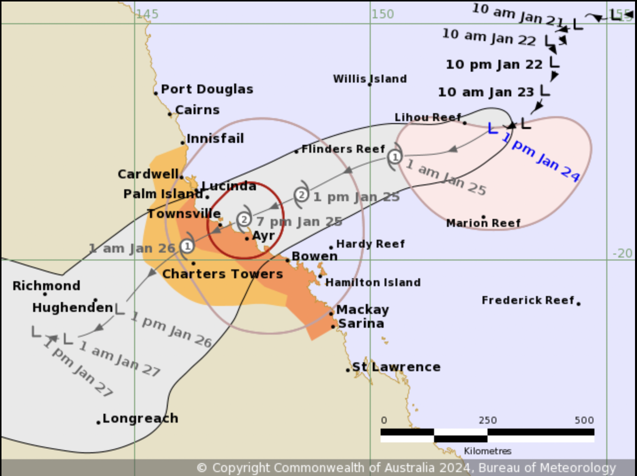
Yellow: watch zone - Orange: warning zone.
Queensland State Disaster Coordinator Deputy Commission Shane Chelepy has asked communities to "make sure your emergency plans are in place".
"The next 24 hours is critical for our communities, all the way down from Cardwell down to the Whitsunday area, to prepare for this crossing. We will start to see strong winds and rain this evening, so the next 12 hours is time for you to do your final preparations," he said on Wednesday morning.
Commissioner Chelepy asked people to prepare with 72 hours worth of food, prepare emergency kits, keep up to date with information services and consider travel plans.
He said emergency services have been deployed, and energy Queensland crews have been staged in Rockhampton.
"Our emergency services have also made contact now with our at risk communities and in low-lying areas to make sure they're aware of the threat to those communities," Commissioner Chelepy said.
"In events like this, it does take up to 72 hours for emergency services and come out and support you in your community.
"Please stay in contact with our local messaging. What we've seen over the last couple of days is this cyclone or this tropical low. has been inconsistent and has been a bit unreliable. We were expecting this tropical low to form into a cyclone two days ago. You know it is moving around a little bit and we won't know for certain the crossing points until it forms."
http://www.bom.gov.au/qld/warnings/
https://www.getready.qld.gov.au/
Emergency Services: Call 000


