

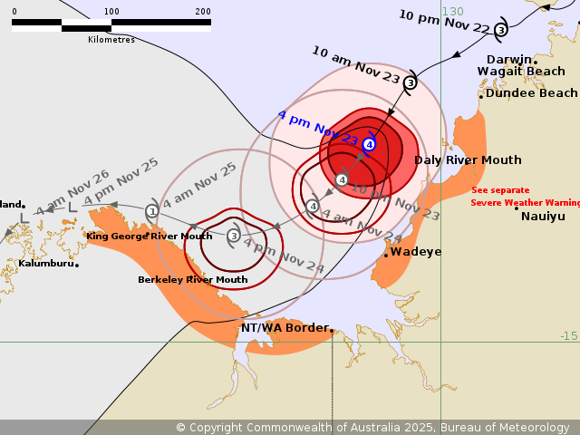
Tropical Cyclone Fina has intensified into a category 4 system, but will begin weakening Monday as it moves southwest towards the north Kimberely coast, the Bureau of Meterology says.
Winds have hit 165 kmph near the centre of the Cyclone with gusts of up to 230 kmph and as of 4:30 Sunday local time was located "well off the west Top End coast".
Its category 4 status was expected to remain on Sunday.
The intensity is expected to ease quickly on Monday, possibly below Cyclone status.
A 'prepare now' status is in place for the the area between the NT/WA border west through to Troughton Island off the Kimberely coast, per Emergency WA.
ABOVE, per BOM 4:30pm local: Red: 'Very destructive' winds - Orange: Warning Zone.
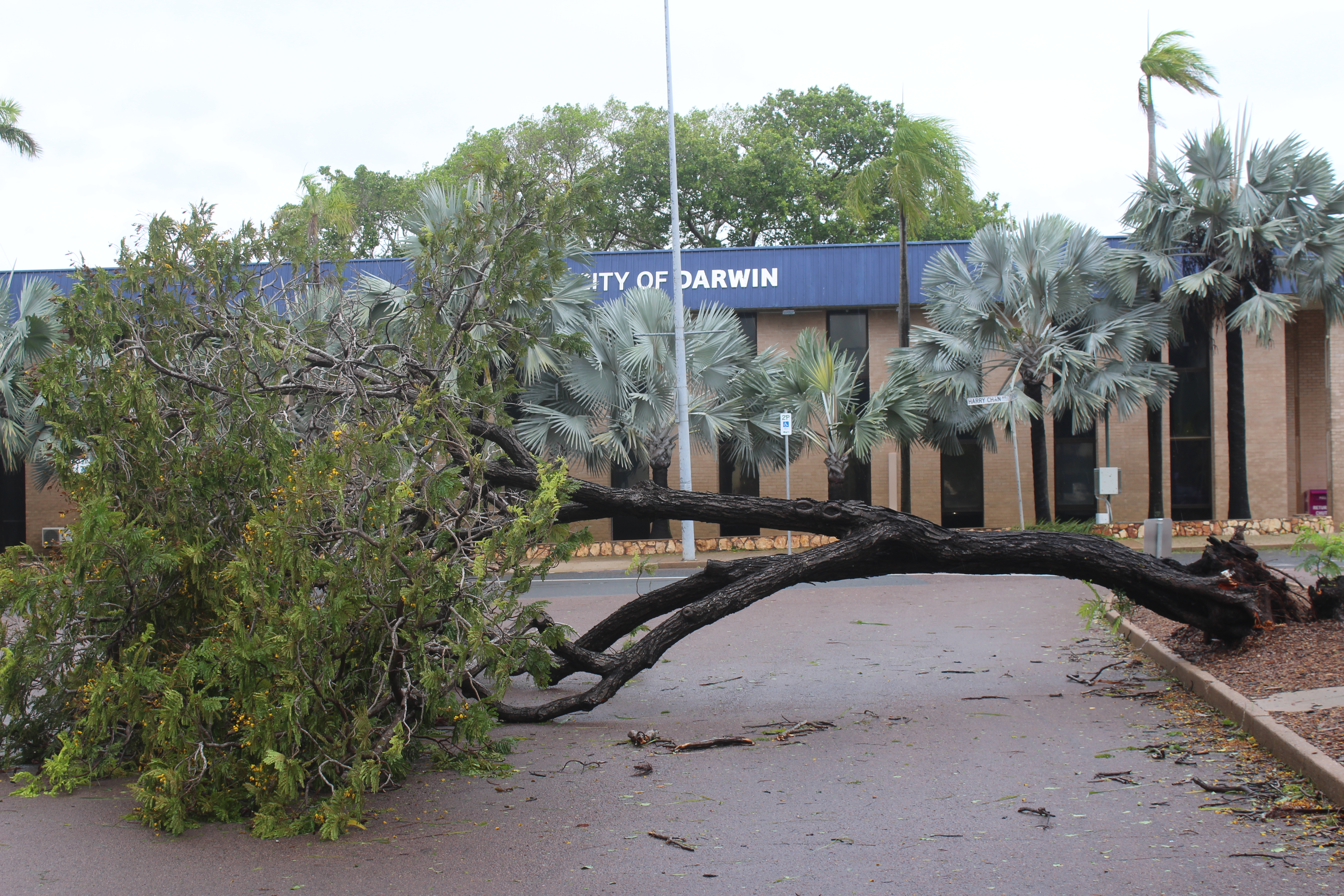
Tropical Cyclone Fina intensified since Saturday, where it hammered Darwin and surrounding areas, including the Tiwi Islands, with heavy rainfall and damaging winds leaving a heavy cleanup.
Close to 20,000 homes were left without power.
Power crews were set to assess outages as of Saturday afternoon.
"HEAVY to LOCALLY INTENSE RAINFALL, which may lead to FLASH FLOODING, about the coastal areas between Dundee Beach to the Daly River Mouth, possibly extending south to Wadeye later on Sunday, then extending southwest to the northeast Kimberley coast later on Monday," the latest BOM updates reads, as of Sunday afternoon.
"Also refer to the adjacent Severe Weather Warning for heavy rainfall over the northwest Top End.
"Coastal residents on the Tiwi Islands, and between Cape Hotham and Warruwi in the Northern Territory are specifically warned that tides may continue to rise above the normal high tide mark on Sunday with LARGE WAVES and MINOR FLOODING of low-lying coastal areas.
"This extends to coastal residents in Western Australia between King George River Mouth and the NT/WA Border for tides on Monday night."
The area between Wadeye to Dundee Beach in the NT, and the border with WA west through to Troughton Island and northern WA community of Kalumburu in the Shire of Wyndham-East Kimberley remain in the warning zone.
People in Dundee Beach to Daly River Mouth "should remain sheltered in a safe place", the Bureau recommends.
"NTES advises people between Daly River Mouth and Wadeye should immediately commence or continue preparations, especially securing boats and property, using available daylight hours," BOM recommends, with direction to Secure NT.
Darwin, Palmerston, Cox Peninsula and Tiwi Islands were recommended to visit Secure NT for post-cyclone safety information.
WA residents have been directed towards www.emergency.wa.gov.au and encouraged to continue referring to updated alerts.
"There remains to be significant debris, trees down and even power lines, but Territorians who need to move about for essential reasons, such as restocking their fridges, having to take items to dump points and other necessary travel are encouraged to do so safely," NT Chief Minister Lia Finocchiaro said from Darwin on Sunday,
In the NT, school principles have been made to assess whether students return on Monday on a "school to school" basis.
Updates to local power are expected Sunday afternoon.


